7.2.3
Causes of Flooding
Test your knowledge with free interactive questions on Seneca — used by over 10 million students.
Human Causes of Flooding
The likelihood of flooding happening can be significantly increased by the actions of humans in that drainage basin.
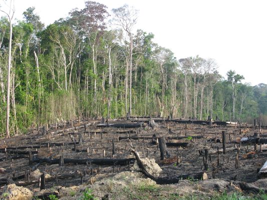
Removal of vegetation
- Deforestation and removal of vegetation increase the risk of flooding in several ways:
- The ground cover decreases, meaning that interception from the plants and their leaves is reduced. This water will now just reach the ground.
- The removal of plants reduces infiltration. With less infiltration and interception, there is an increase in surface runoff.

Agriculture
- As demand for food increases, so does demand for agricultural land. Increasingly farms are made on deforestation sites, for example in the Amazon.
- Agricultural practices increase surface runoff and the amount of soil exposed - leading to soil erosion. Sediment from the erosion is transported to the river.
- The river's water capacity is reduced by the sediment, increasing the likelihood that the river will burst its banks.

Urbanisation
- Urbanisation leads to the removal of vegetation resulting in an increase in surface runoff.
- An increase in impermeable man-made surfaces - i.e. concrete, tarmac and tiles - lead to no infiltration and so all rainfall experiences runoff.
- Runoff enters the drainage system which quickly takes the water to rivers and waterways. This significantly reduces the lag time and promotes reaching a high peak discharge.

Floodplain drainage
- Floodplain land is flat and fertile, making it desirable agricultural land but a target for floods.
- In many countries, this land is drained to provide this. But the process of drying out the wetlands destroys habitats.
- The drying out process leads to the area shrinking and lowering, which can actually increase the likelihood of the areas being subject to floods.

River management
- River management (especially that of hard engineering systems) is meant to provide protection from flooding. But poor river management can have the opposite effect.
- Channelisation (when the river is widened or deepened) and straightening the river (by cutting off meanders) has actually increased flood risk on the River Mississippi. The levees and man-made channels restrict the river, making it more likely to burst its banks.
Meteorological Causes of Flooding
Natural flooding is caused when a rivers discharge increases until the river bursts its banks. Flooding can be caused by an increase in rainfall or an increase in surface runoff water.

Flash flooding
- Flash floods happen quickly and frequently without warning.
- Low air pressure systems can create intense tropical storms and thunderstorms that produce heavy rainfall.

Prolonged and heavy rainfall
- Prolonged and heavy rainfall can be caused by mid-latitude depressions (low air pressure systems that produce a lot of rain).
- A depression happens when two air masses meet, one hot and one cold. The cold air pushes the hot air up, leading to its cooling, condensing and forming rain.
- Heavy rains can lead to saturated soil, which stops infiltration and increases surface runoff. Water reaches the channel quicker and causes flooding.
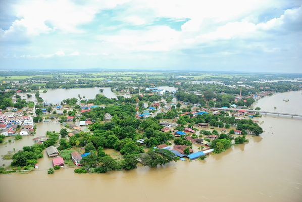
Extreme monsoon rainfall
- A monsoon is a seasonal change in the direction of the prevailing winds as the ITCZ (Inter Tropical Convergence Zone) moves northwards.
- The change results in wet and dry seasons in subtropical areas that are close to oceans. Because of this, India and South East Asia are at particular risk.
- The summer monsoon (April-September) leads to extreme rainfall in India and South East Asia. During July 2015, the heavy monsoon rain resulted in 103 deaths in Myanmar.

Snowmelt
- When temperatures increase after winter, snow and ice in higher latitudes or altitudes will begin to melt.
- Snowmelt is particularly evident in mountain environments and the increase in water results in increased surface runoff and consequential flash floods.

ENSO: La Niña
- La Niña is a change in weather pattern across the South Pacific Ocean as part of the El Niño Southern Oscillation (ENSO) cycles.
- La Niña events exaggerate the normal weather patterns. The La Nina years bring warm water and low air pressure to Australasia so the rainfall increases, as does the risk of flooding.
1Tectonic Processes & Hazards
1.1Tectonic Processes & Hazards
1.2Natural Disasters
1.3Natural Disaster Case Studies
1.4Trends & Patterns
2Option 2A: Glaciated Landscapes & Change
2.1Glaciated Landscapes Over Time
2.2Periglacial Landscapes
2.3Glacial Processes
2.4Glacial Landforms
3Option 2B: Coastal Landscapes & Change
3.1Coastal Landscapes
3.2Coastal Erosion & Deposition
3.3Coastal Risks
4Globalisation
4.1Globalisation
4.2Negatives of Globalisation
4.3Global Shift
4.5Culture
4.6Measuring Development
5Option 4A: Regenerating Places
5.1Types of Economies
5.2Function of Places
5.3Regeneration
5.4Regeneration Case Studies
6Option 4B: Diverse Places
6.1Population Structure
6.2Past & Present Connections
6.3Urban & Rural Spaces
6.4Diversity
6.5Urban & Rural Case Studies
6.6Case Study - Tower Hamlets
6.7Case Study - Sturton-le-Steeple
7The Water Cycle & Water Insecurity (A2 only)
7.1Hydrological Processes Global to Local
7.2Influences on the Water Cycle
7.3Water Insecurity
8The Carbon Cycle & Energy Security (A2 only)
8.1The Carbon Cycle
8.2Energy Consumption
8.3Alternative Energy
8.4Growing Demand for Resources
9Superpowers (A2 only)
9.1Superpowers
9.2Hard & Soft Power
9.2.1Hard & Soft Power9.2.2Emerging Powers - China Rivalry9.2.3Emerging Powers - Chinese Sources of Power9.2.4Emerging Powers - Brazil9.2.5Emerging Powers - Russia9.2.6Emerging Powers - India9.2.7Theories of Development9.2.8Power Case Studies: Chinese One Belt One Road9.2.9Power Case Studies: Pakistan Nuclear Arms9.2.10Power Case Studies: OPEC
9.3IGOs, TNCs & Alliances
10Option 8A: Health & Human Rights (A2 only)
10.1Human Development
10.2Role of Governments & IGOs
10.3Human Rights
10.4Interventions
11Option 8B: Migration & Identity (A2 only)
11.1Globalisation & Migration
11.2Consequences of Migration
11.3Nation States
11.4Responses to Global Migration
Jump to other topics
1Tectonic Processes & Hazards
1.1Tectonic Processes & Hazards
1.2Natural Disasters
1.3Natural Disaster Case Studies
1.4Trends & Patterns
2Option 2A: Glaciated Landscapes & Change
2.1Glaciated Landscapes Over Time
2.2Periglacial Landscapes
2.3Glacial Processes
2.4Glacial Landforms
3Option 2B: Coastal Landscapes & Change
3.1Coastal Landscapes
3.2Coastal Erosion & Deposition
3.3Coastal Risks
4Globalisation
4.1Globalisation
4.2Negatives of Globalisation
4.3Global Shift
4.5Culture
4.6Measuring Development
5Option 4A: Regenerating Places
5.1Types of Economies
5.2Function of Places
5.3Regeneration
5.4Regeneration Case Studies
6Option 4B: Diverse Places
6.1Population Structure
6.2Past & Present Connections
6.3Urban & Rural Spaces
6.4Diversity
6.5Urban & Rural Case Studies
6.6Case Study - Tower Hamlets
6.7Case Study - Sturton-le-Steeple
7The Water Cycle & Water Insecurity (A2 only)
7.1Hydrological Processes Global to Local
7.2Influences on the Water Cycle
7.3Water Insecurity
8The Carbon Cycle & Energy Security (A2 only)
8.1The Carbon Cycle
8.2Energy Consumption
8.3Alternative Energy
8.4Growing Demand for Resources
9Superpowers (A2 only)
9.1Superpowers
9.2Hard & Soft Power
9.2.1Hard & Soft Power9.2.2Emerging Powers - China Rivalry9.2.3Emerging Powers - Chinese Sources of Power9.2.4Emerging Powers - Brazil9.2.5Emerging Powers - Russia9.2.6Emerging Powers - India9.2.7Theories of Development9.2.8Power Case Studies: Chinese One Belt One Road9.2.9Power Case Studies: Pakistan Nuclear Arms9.2.10Power Case Studies: OPEC
9.3IGOs, TNCs & Alliances
10Option 8A: Health & Human Rights (A2 only)
10.1Human Development
10.2Role of Governments & IGOs
10.3Human Rights
10.4Interventions
11Option 8B: Migration & Identity (A2 only)
11.1Globalisation & Migration
11.2Consequences of Migration
11.3Nation States
11.4Responses to Global Migration
Practice questions on Causes of Flooding
Can you answer these? Test yourself with free interactive practice on Seneca — used by over 10 million students.
- 1
- 2What are the characteristics of flash flooding?Multiple choice
- 3What is the ITCZ?Multiple choice
- 4Impacts of snowmelt:Fill in the list
Unlock your full potential with Seneca Premium
Unlimited access to 10,000+ open-ended exam questions
Mini-mock exams based on your study history
Unlock 800+ premium courses & e-books