9.2.2
Case Study: The Holderness Coast
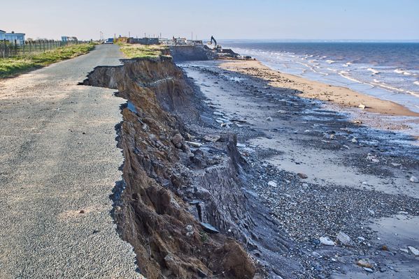
Coastal Erosion in Holderness
Coastal Erosion in Holderness
The Holderness coast is located next to the city of Hull in the north-east of England. Each year, the Holderness Coast retreats 1-2 metres. The area is particularly vulnerable to erosion because of:

Strong prevailing winds
Strong prevailing winds
- Strong prevailing winds create destructive waves that can do more damage to the coast.
- The prevailing winds also mean that any eroded material moves away from the place that was eroded (leaving the soft rock exposed).

Clay cliffs
Clay cliffs
- The Holderness Coast is made of boulder clay.
- This is very soft and easy to erode.
- Heavy rainfall can cause mass movements in the boulder clay cliffs.
Coastal Management in Holderness
Coastal Management in Holderness
In 1991, a £2 million project built rock groynes and rock revetments at Mappleton in the Holderness coast. These are examples of hard engineering.
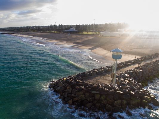
Rock groynes
Rock groynes
- The rock groynes tried to stop sediment being carried away from the Holderness Coast and tried to create a larger beach to protect the land behind.
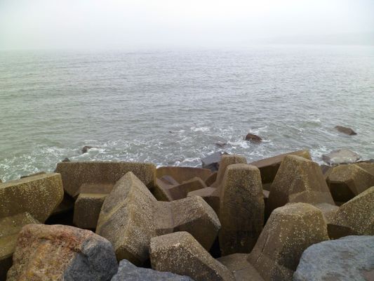
Rock armour
Rock armour
- Rock armour was placed at the foot of the cliffs.
- The rock armour is meant to absorb some of the waves' energy, instead of the coast or cliffs.
What are the Results & Effects of Coastal Management at Mappleton?
What are the Results & Effects of Coastal Management at Mappleton?
The cliffs at Mappleton now erode at 1-2 metres per year, instead of the 7-10 metres before 1991. Mappleton now has a larger beach, however, there have been some negative effects:
Area south of Mappleton
Area south of Mappleton
- The area south of Mappleton is experiencing faster coastal erosion as a byproduct.
Spurn Point
Spurn Point
- The Spurn Point area south, has become less secure.
- Less material is washed down the Holderness Coast.
- Some Hebridean Sheep were washed away and killed. People are now warned not to visit the Point at some times of year, or they too could be washed away.
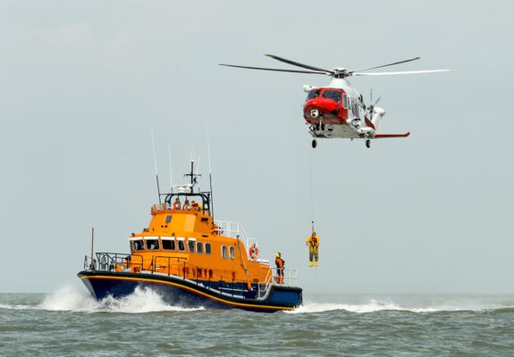
Spurn Point lifeboat & visitor's centre
Spurn Point lifeboat & visitor's centre
- £471,000 was spent on a visitor's centre which could become less accessible over time.
- Lifeboat services also operate from Spurn Point.
1Geography Skills
1.1Mapping
2Geology of the UK
2.1The UK's Rocks
2.2Case Study: The Peak District
3Geography of the World
4Development
4.1Development
4.2Uneven Development
4.3Case Study: Democratic Republic of Congo
5Weather & Climate
5.1Weather
5.1.1Weather & Climate
5.1.2Components of Weather
5.1.3Temperature
5.1.4Sunshine, Humidity & Air Pressure
5.1.5Cloud Cover
5.1.6Precipitation
5.1.7Convectional Precipitation
5.1.8Frontal Precipitation
5.1.9Relief or Orographic Precipitation
5.1.10Wind
5.1.11Extreme Wind
5.1.12Recording the Weather
5.1.13Extreme Weather
5.1.14Weather Hazards - Statistical Skills
5.2Climate
6The World of Work
7Natural Resources
7.1Rocks
8Rivers
8.1River Processes & Landforms
8.1.1Overview of Rivers
8.1.2The Bradshaw Model
8.1.3Erosion
8.1.4Sediment Transport
8.1.5River Deposition
8.1.6Landforms
8.1.7River Profiles: Long Profiles
8.1.8River Profiles: Cross Profiles
8.1.9Waterfalls & Gorges
8.1.10Interlocking Spurs
8.1.11Meanders
8.1.12Floodplains
8.1.13Levees
8.1.14Case Study: River Tees
8.2Rivers & Flooding
8.2.1Flood Risk Factors
8.2.2Flood Management: Hard Engineering
8.2.3Flood Management: Soft Engineering
8.2.4Flooding Case Study: Boscastle
8.2.5Flooding Case Study: Consequences of Boscastle
8.2.6Flooding Case Study: Responses to Boscastle
8.2.7Flooding Case Study: Bangladesh
8.2.8Flooding Case Study: Bangladesh - Consequences
8.2.9End of Topic Test - Rivers
8.2.10Rivers Case Study: The Nile
8.2.11Rivers Case Study: The Mississippi
9Coasts
9.1Formation of Coastal Landforms
10Glaciers
10.1Overview of Glaciers & How They Work
10.1.1Distribution of Glaciers
10.1.2Types of Glaciers
10.1.3The Last Ice Age
10.1.4Formation & Movement of Glaciers
10.1.5Shaping of Landscapes by Glaciers
10.1.6Glacial Landforms Created by Erosion
10.1.7Glacial Till & Outwash Plain
10.1.8Moraines
10.1.9Drumlins & Erratics
10.1.10End of Topic Tests - Glaciers
10.1.11Tourism in Glacial Landscapes
10.1.12Strategies for Coping with Tourists
10.1.13Case Study - Lake District: Tourism
10.1.14Case Study - Lake District: Management
11Tectonics
11.1Continental Drift & Plate Tectonics
11.2Volcanoes
11.3Earthquakes
11.5Managing the Risk of Volcanoes & Earthquakes
12Climate Change
12.1The Causes & Consequences of Climate Change
12.1.1Evidence for Climate Change
12.1.2Natural Causes of Climate Change
12.1.3Human Causes of Climate Change
12.1.4The Greenhouse Effect
12.1.5Effects of Climate Change on the Environment
12.1.6Effects of Climate Change on People
12.1.7Climate Change Predictions
12.1.8Uncertainty About Future Climate Change
12.1.9Mitigating Against Climate Change
12.1.10Adapting to Climate Change
12.1.11Case Study: Bangladesh
12.1.12Climate Change - Statistical Skills
13Global Population & Inequality
14Urbanisation
14.1Urbanisation
14.1.1Rural Characterisitcs
14.1.2Urban Characteristics
14.1.3Urbanisation Growth
14.1.4The Land Use Model
14.1.5Rural-Urban Pull Factors
14.1.6Rural-Urban Push Factors
14.1.7The Impacts of Migration
14.1.8Challenges of Urban Areas in Developed Countries
14.1.9Challenges of Urban Areas in Developing Countries
14.1.10Urban Sustainability
14.1.11Case Study: China's Urbanisation
14.1.12Major UK Cities
14.1.13Urbanisation in the UK
14.1.14End of Topic Test- Urbanisation
14.1.15End of Topic Test - Urban Issues
14.1.16Urban Issues - Statistical Skills
15Ecosystems
15.1The Major Biomes
15.2Case Study: The Amazon Rainforest
15.2.1Interdependence of Rainforest Ecosystems
15.2.2Nutrient Cycling in Tropical Rainforests
15.2.3Deforestation in the Amazon
15.2.4Impacts of Deforestation in the Amazon
15.2.5Protecting the Amazon
15.2.6Adaptations of Plants to Rainforests
15.2.7Adaptations of Animals to Rainforests
15.2.8Deforestation - Statistical Skills
16Life in an Emerging Country
16.1Case Studies
17Analysis of Africa
17.1Africa
17.1.1Desert Biomes in Africa
17.1.2The Semi-Desert Biome
17.1.3The Savanna Biome
17.1.4Overview of Tropical Rainforests
17.1.5Colonisation History
17.1.6Population Distribution in Africa
17.1.7Economic Resources in Africa
17.1.8Urbanisation in Africa
17.1.9Africa's Location
17.1.10Physical Geography of Africa
17.1.11Desertification in Africa
17.1.12Reducing the Risk of Desertification
17.1.13Case Study: The Sahara Desert - Opportunities
17.1.14Case Study: The Sahara Desert - Development
18Analysis of India
18.1India - Physical Geography
19Analysis of the Middle East
19.1The Middle East
19.1.1Physical Geography of the Middle East
19.1.2Human Geography of the Middle East
19.1.3Climate Zones in the Middle East
19.1.4Climate Comparison with the UK
19.1.5Oil & Natural Gas in the Middle East
19.1.6Water in the Middle East
19.1.7Population of the Middle East
19.1.8Development Case Studies: The UAE
19.1.9Development Case Studies: Yemen
19.1.10Supporting Development in Yemen
19.1.11Connection to the UK
19.1.12Importance of Oil
19.1.13Oil & Tourism in the UAE
20Analysis of Bangladesh
20.1Bangladesh Physical Geography
21Analysis of Russia
21.1Russia's Physical Geography
21.2Russia's Human Geography
Jump to other topics
1Geography Skills
1.1Mapping
2Geology of the UK
2.1The UK's Rocks
2.2Case Study: The Peak District
3Geography of the World
4Development
4.1Development
4.2Uneven Development
4.3Case Study: Democratic Republic of Congo
5Weather & Climate
5.1Weather
5.1.1Weather & Climate
5.1.2Components of Weather
5.1.3Temperature
5.1.4Sunshine, Humidity & Air Pressure
5.1.5Cloud Cover
5.1.6Precipitation
5.1.7Convectional Precipitation
5.1.8Frontal Precipitation
5.1.9Relief or Orographic Precipitation
5.1.10Wind
5.1.11Extreme Wind
5.1.12Recording the Weather
5.1.13Extreme Weather
5.1.14Weather Hazards - Statistical Skills
5.2Climate
6The World of Work
7Natural Resources
7.1Rocks
8Rivers
8.1River Processes & Landforms
8.1.1Overview of Rivers
8.1.2The Bradshaw Model
8.1.3Erosion
8.1.4Sediment Transport
8.1.5River Deposition
8.1.6Landforms
8.1.7River Profiles: Long Profiles
8.1.8River Profiles: Cross Profiles
8.1.9Waterfalls & Gorges
8.1.10Interlocking Spurs
8.1.11Meanders
8.1.12Floodplains
8.1.13Levees
8.1.14Case Study: River Tees
8.2Rivers & Flooding
8.2.1Flood Risk Factors
8.2.2Flood Management: Hard Engineering
8.2.3Flood Management: Soft Engineering
8.2.4Flooding Case Study: Boscastle
8.2.5Flooding Case Study: Consequences of Boscastle
8.2.6Flooding Case Study: Responses to Boscastle
8.2.7Flooding Case Study: Bangladesh
8.2.8Flooding Case Study: Bangladesh - Consequences
8.2.9End of Topic Test - Rivers
8.2.10Rivers Case Study: The Nile
8.2.11Rivers Case Study: The Mississippi
9Coasts
9.1Formation of Coastal Landforms
10Glaciers
10.1Overview of Glaciers & How They Work
10.1.1Distribution of Glaciers
10.1.2Types of Glaciers
10.1.3The Last Ice Age
10.1.4Formation & Movement of Glaciers
10.1.5Shaping of Landscapes by Glaciers
10.1.6Glacial Landforms Created by Erosion
10.1.7Glacial Till & Outwash Plain
10.1.8Moraines
10.1.9Drumlins & Erratics
10.1.10End of Topic Tests - Glaciers
10.1.11Tourism in Glacial Landscapes
10.1.12Strategies for Coping with Tourists
10.1.13Case Study - Lake District: Tourism
10.1.14Case Study - Lake District: Management
11Tectonics
11.1Continental Drift & Plate Tectonics
11.2Volcanoes
11.3Earthquakes
11.5Managing the Risk of Volcanoes & Earthquakes
12Climate Change
12.1The Causes & Consequences of Climate Change
12.1.1Evidence for Climate Change
12.1.2Natural Causes of Climate Change
12.1.3Human Causes of Climate Change
12.1.4The Greenhouse Effect
12.1.5Effects of Climate Change on the Environment
12.1.6Effects of Climate Change on People
12.1.7Climate Change Predictions
12.1.8Uncertainty About Future Climate Change
12.1.9Mitigating Against Climate Change
12.1.10Adapting to Climate Change
12.1.11Case Study: Bangladesh
12.1.12Climate Change - Statistical Skills
13Global Population & Inequality
14Urbanisation
14.1Urbanisation
14.1.1Rural Characterisitcs
14.1.2Urban Characteristics
14.1.3Urbanisation Growth
14.1.4The Land Use Model
14.1.5Rural-Urban Pull Factors
14.1.6Rural-Urban Push Factors
14.1.7The Impacts of Migration
14.1.8Challenges of Urban Areas in Developed Countries
14.1.9Challenges of Urban Areas in Developing Countries
14.1.10Urban Sustainability
14.1.11Case Study: China's Urbanisation
14.1.12Major UK Cities
14.1.13Urbanisation in the UK
14.1.14End of Topic Test- Urbanisation
14.1.15End of Topic Test - Urban Issues
14.1.16Urban Issues - Statistical Skills
15Ecosystems
15.1The Major Biomes
15.2Case Study: The Amazon Rainforest
15.2.1Interdependence of Rainforest Ecosystems
15.2.2Nutrient Cycling in Tropical Rainforests
15.2.3Deforestation in the Amazon
15.2.4Impacts of Deforestation in the Amazon
15.2.5Protecting the Amazon
15.2.6Adaptations of Plants to Rainforests
15.2.7Adaptations of Animals to Rainforests
15.2.8Deforestation - Statistical Skills
16Life in an Emerging Country
16.1Case Studies
17Analysis of Africa
17.1Africa
17.1.1Desert Biomes in Africa
17.1.2The Semi-Desert Biome
17.1.3The Savanna Biome
17.1.4Overview of Tropical Rainforests
17.1.5Colonisation History
17.1.6Population Distribution in Africa
17.1.7Economic Resources in Africa
17.1.8Urbanisation in Africa
17.1.9Africa's Location
17.1.10Physical Geography of Africa
17.1.11Desertification in Africa
17.1.12Reducing the Risk of Desertification
17.1.13Case Study: The Sahara Desert - Opportunities
17.1.14Case Study: The Sahara Desert - Development
18Analysis of India
18.1India - Physical Geography
19Analysis of the Middle East
19.1The Middle East
19.1.1Physical Geography of the Middle East
19.1.2Human Geography of the Middle East
19.1.3Climate Zones in the Middle East
19.1.4Climate Comparison with the UK
19.1.5Oil & Natural Gas in the Middle East
19.1.6Water in the Middle East
19.1.7Population of the Middle East
19.1.8Development Case Studies: The UAE
19.1.9Development Case Studies: Yemen
19.1.10Supporting Development in Yemen
19.1.11Connection to the UK
19.1.12Importance of Oil
19.1.13Oil & Tourism in the UAE
20Analysis of Bangladesh
20.1Bangladesh Physical Geography
21Analysis of Russia
21.1Russia's Physical Geography
21.2Russia's Human Geography
Unlock your full potential with Seneca Premium
Unlimited access to 10,000+ open-ended exam questions
Mini-mock exams based on your study history
Unlock 800+ premium courses & e-books